It was getting late in August, and since I had brought some camping gear from Ontario; it was time to go out for a short Sea Pearl camping trip. In PEI, there are not very many great camping SP areas. Malpeque Bay is the best one in western PEI. It's relatively isolated, somewhat protected, and big enough for a few days. It's protected from the Gulf's big waters, but, with the right winds, the Bay can get quite rough and choppy.
 |
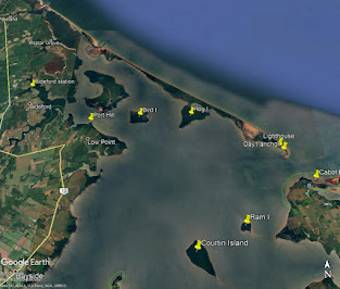
| Malpeque Bay, PEI |
On Aug 20th, I drove to the ramp at the Bideford station (near Ellerslie). The ramp fee is $10/use. After launching the Sea Pearl, I went back home to drop off the trailer, and Anne drove me back to Bideford. From Bideford, I motored to the shore at Port Hill (about 5km).
After setting sails, I headed out in Malpeque Bay towards Ram Island. The winds were out of the south and not very strong (10-15 km/hr). Before reaching Ram Island, the low tidal waters forced me to turn NE towards the Malpeque channel entrance. By mid-afternoon, I had reached the little bay near the old Malpeque lighthouse on Fish Island (about 12km from the Port Hill shore). This would be my anchorage for the first night. It's a lovely shallow bay, but there's no protection if the winds get strong from the south or west (which they tend to do in the summer)!
Weather permitting, Malpeque Harbour (Darnley Basin) may be a better place to spend the night next time -- or bring a tent and sleep ashore.
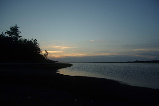
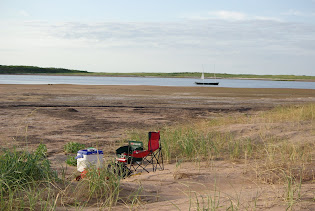
That was it for Day 1 sailing. I spend the rest of the day exploring the area (e.g. old lighthouse), walking on the sandhill, photography, and dinner—a pretty good first day to my SP camping trip. The night wasn't as good. The wind came up a bit (SSE 12km/hr) and interrupted my sleep. The SP is pretty light, so it doesn't take much wave action to rock the boat. That would be another good reason to sleep ashore in a tent.
 | | SP21 resting in Fish Island bay |
|
 | | Old lighthouse, Fish Island |
|
Day 2 (Aug
21st)
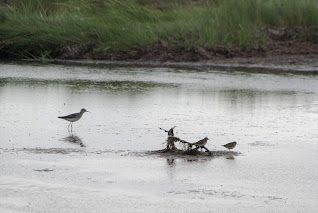
On Aug 21st, I awoke to a calm morning, and it stayed pretty calm until mid-afternoon. After breakfast on the beach, I crossed over to Cabot Park to look around and got some boat maintenance done (e.g. deck clean up). After seeing some fishing boats in the Malpeque channel (I assume mackerel), I decided to try my luck. I had a hard time finding deep water and didn't want to go too far into the Gulf. There were no bites, so it was time to set sail and make for Ram Island. I got to Ram Island with a very light breeze after an hour or so, and it was almost time for lunch (4.5km). Before lunch, I had a good walk around the island and was surprised to see that the cormorant colony is mostly gone! I did see one bald eagle flying around.
After lunch, the winds suddenly came up, so it was time to make for Hog Island's NE corner (Iron Rock). The 7 km sail to Iron Rock was great, with a good breeze coming out of the south (15 km/hr). I anchored the SP off the sandhill shore and walked across to the Gulf side. I did see poison ivy in places, so you have to be very attentive to any low vegetation that is not seagrass! After a nice walk on the beach, I returned to the SP and crossed over to Iron Rock point, planning to spend the night. The winds got stronger from the SSE, and it was getting iffy if the point was the best anchoring spot for the night. I did have a look further in the shallow back bay but failed to find a better anchorage. After dinner and a bit of exploring/photography, I went to bed aboard the SP. It was another night of interrupted sleep from a rocking boat and wind noises (S 20km/hr). Again, sleeping ashore in a tent would have been much better! I'm not sure that camping on Hog Island's shores is allowed without the permission of the Mi'kmaq people.
 | | Cabot Provincial Park |
|
 | | Cabot Provincial Park (south of) |
|
 | | Iron Rock, Hog Island |
|
 | | The channel behind Hog Island |
|
Day 3 (Aug
22nd)
Early on the morning of Aug 22nd, the wind was quite strong from the south (20km/hr) and was probably going to get stronger as the day heated up. So I decided to make for the more protected shores of Low Point for breakfast. To save time, I motored upwind until I was cleared of Hog Island, then set sails and had a fast beam reach to Low Point. There was 2-3 ft of chop on Malpeque Bay, and I had to head-up a few times to avoid broadsiding a few large waves. A bit too much excitement before my morning coffee!
At Low Point, I had a cold breakfast and then crossed over to the west side of Bird Island and went for a walk. I had a great walk on the west and south sides and briefly saw the second bald eagle of my trip. From Bird Island, I sailed/motored back to the ramp at Bideford station (7.5 km). I called Anne to come and pick me up, drove to the cottage to get the boat trailer, and then back to the Bideford station to get the Sea Pearl and gear. I was home by late afternoon – somewhat exhausted from my two nights of interrupted sleep.
In good weather, Sea Pearl camping in Malpeque Bay is fun, assuming the winds are modest, tides are cooperating, and there’s low mosquito density. It’s tricky to get all four of these conditions in PEI’s short summer. I had pretty good conditions on this trip – except for the higher winds on the 3rd day. Lots of shallow waters in Malpeque Bay, so higher day tides would have been great, but the mosquitos were OK, so it’s hard to complain!
Overall, I learned a lot about sailing the upper Malpeque Bay in various southerly winds and changing tides. A great SP trip and my first time camping at Fish Island!


