Sunday, 30 July 2023

Up the Brae River, Egmont Bay, PEI


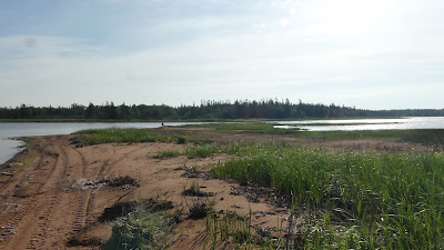
The Brae River is another small river that flows into Egmont Bay (near Brae Harbour). This summer (2023), I was planning to paddle and explore all the rivers of Egmont Bay. For some reason, this would be my first paddle ever up the small, winding Brae River. You could access the river at the Beaton Road bridge, but it would be challenging. So, instead, I decided to put-in/out at the end of Campbell Shore Road. From Campbell Shore Road, it’s a 1 km east paddle to the mouth/estuary of the Brae River.

Track, Brae River, 8km, 30Jul2023

Once inside the estuary, it’s another kilometre to the Beaton Road bridge. This river stretch is about 20-30m wide with some marsh shorelines, forested shorelines, and farm/crop fields. There are also two homesteads along the western side of the river (before the bridge). The church, rectory, and Immaculate Conception Brae cemetery are just west of the bridge on Beaton Road. 

Brae River and marsh, the Beaton Rd church in the background

After the bridge, there are no more structures, but the narrow river is never too far from farmland. The marsh grass and cattails were so tall on this paddle that the farm fields were not visible from the water. As I was zig-zagging up the Brae, I kept running into American Black Ducks. These ducks appeared surprised and shocked – they probably don’t get too much kayak traffic in those narrow sections of the river/creek.

The upper Brae River (the navigable end)

The Brae River was lovely to paddle even though it’s not an entire natural environment. It would be great to try the same paddle early in the spring to see more flora & fauna (especially birds).


American Black Duck


American Black Duck


Cedar Waxwing


Greater Yellowlegs


Thursday, 27 July 2023

Nebraska Creek, Grand River, PEI


Nebraska Creek was a new kayaking destination for me in 2023. I have paddled and sailed on most of the Grand River but never ventured up the Nebraska Creek tributary. Nebraska Creek flows from the Miscouche peat lands off the Western Road to the Grand River, which flows NE into Malpeque Bay.

Track, 7km, 27Jul2023

The launch is just east of the Route 12 bridge. There’s an access trail to the water’s edge, but it requires a truck or 4WD vehicle. With Anne’s Toyota Corolla, I unloaded the kayak on Route 12 and used my 2-wheel kayak cart for the 100m trek to the creek. After launching, I checked the cottages, cabins, and trailers in the large creek/inlet to the east that borders the Nebraska Road. The water was very shallow and weedy in the east channel, so I did not make it all the way to the Nebraska Road bridge. Most structures (cottages/cabins, sheds, etc.) that border Nebraska Road don’t look great, and some appear abandoned.


After exiting the east side inlet, I headed upstream (south), following the east shore to better inspect INT’s Nebraska Creek Natural Area. In paddling upstream, the creek feels pretty isolated and undisturbed (from the seat of a kayak). But, on Google Earth, you can see large areas of logging (especially on the western side). Also, less than 1 km to the south of where I was paddling is the large commercial Miscouche Peat mine (150 acres). And to the west (about 2 km) is the East Prince Waste Management Facility (i.e. the dump).  

The lower Nebraska Creek

I paddled about 2.5 km up the creek before being blocked by low water levels and debris. The stream was turning eastward at this point, and another 300m or so, I would have reached a beaver dam/pond area. On the upper stretch of Nebraska Creek, there is only one development – one cottage/home on the west bank with a 500m access from Route 122 (Allen Rd). The property seems to include a small man-made pond near the creek.

The upper Nebraska Creek

The iNaturalist postings for the day can be found by clicking HERE.

The Nebraska Creek paddle was quite good once I left the cottage/cabin area. I signed up with INT as the prime Guardian for the MapleCross Nebraska Creek NA, so I’ll be back on a yearly basis. Next year, try to reach the upper creek at the peak of high tides/waters.


Belted Kingfisher


Solitary Sandpiper

Note 1: The Route 12 Nebraska Creek wooden bridge looks pretty scary from under. I hope it’s on the repair/replacement list sooner rather than later!

Note 2: Nebraska is of aboriginal origin (North America) and means “flat water.” I don’t know if that was the Mi’kmaq local meaning or how the Nebraska Creek came to have its name.


Sunday, 9 July 2023

The Ox and Sheep Rivers, PEI


The Ox and Sheep Rivers are two small streams flowing into the Enmore/Percival estuary and Egmont Bay. Due to their size, it’s hard to call them rivers, but that shows up on all the maps. Creeks would be a better match to other streams in the area (e.g. Beatons Creek, Baptiste Creek, etc). 

Track, 7.5km, 09Jul2023

On this outing, I launched my WD12 kayak at Higgins Wharf to reach the mouth of the two small rivers. The other put-in option is the end of Moore Road (Yeos Shore). Moore Road is a slightly longer paddle to the Ox/Sheep Rivers, but it would be a better launch site. Higgins Wharf can be a mess, smelly, and busy sometimes. The day was somewhat hazy when I started from Higgins Wharf, but it eventually cleared up. Unfortunately, the tide was going down, so I did not waste too much time getting up the Ox River. I had no problem getting to the Route 11 bridge, but 200m further upstream, the way was blocked by a large tree. The south side of the Ox River is mostly farm fields but no building structures. 

Common Tern

I tried to go up the Sheep River on the return paddle, but the water level was too low. So, it was a quick paddle back out of the Ox/Sheep estuary before getting stuck in the bottom mud. On returning to Higgins Wharf, I went by an oyster aquaculture. I got some scenery photos and the usual close-up pics of Cormorants resting on the black flotation boxes.

Double-crested Cormorants hanging out

The iNaturalist postings for the day can be found by clicking HERE.

The Ox/Sheep River paddle was a bit more interesting than I would have thought. I will do it again but at higher water/tide levels.


The lower Ox River


The upper Ox River (just east of Route 11 bridge)


Sunday, 2 July 2023

Jacques River, Baie-Egmont, PEI


The Jacques River is the closest to our summer home in St. Chrysostome (aka Rocky Point). The Jacques River is also the only river in PEI that I’ve been able to do a loop outing (it only requires a 700m walk).


Track, Jacques River loop, 5km

The put-in is at the end of Cimetiere Road on Egmont Bay. The Cimetiere Road is also a place to launch my Va’a Motu outrigger sailing canoe. The put-out is the Arsenault Pond, and then a 700m walk back to the end of Cimetiere Road (and your vehicle). This paddle (as most small rivers in PEI) is best done at high tides. Ideally, for small PEI rivers, you should plan to be heading upriver an hour before high tide and end the paddle 2 to 3 hours after high tide. 

Jacques River estuary into Egmont Bay

The paddle from Cimetiere Road to the mouth of the Jacques River is about one km. On this paddle, I landed on the sandy shore just south of the river’s entrance/estuary. Before I started again, seeing an Osprey circling and fishing over the bay just out from the river was great.

The south creek salt-marsh

The most natural part of the paddle is the first kilometre or so – before you get to the farm fields, homes, and roads. The first kilometre has two side creeks/marshes to explore. The south one (towards McGee Road) is more remote and quite lovely. The east creek goes towards Route 11. I did spot a Muskrat in the east stream, but he disappeared before a photo could be taken. By early July, both creeks were somewhat blocked by marsh grass & cattails. I’ll have to try this paddle early in the spring on a high/spring tide to see how much further it’s possible to paddle on those creeks.


East creek


Blue Flag Lily

After the east creek, it’s not more than 1.5 km to the Arsenault Pond. The river gets narrower and goes under two bridges before reaching the pond. The Route 11 bridge is older and relatively low – it could be trouble when the water level is a bit higher.

The iNaturalist postings for the day can be found by clicking HERE.

An Osprey fishing in Egmont Bay at the mouth of the Jacques River