Thursday, 29 September 2022

Paddling & exploring on the Enmore River


The Department of the Environment for PEI has the Enmore River labelled as having excellent water quality. This is not hard to believe. Every time that I go paddling on the Enmore River, I feel that this small river is still pristine! The Enmore is currently unspoiled by farming, fishing, or any other kinds of industries. There has been logging in the area over the years but there’s nothing large-scale taking place at the moment. 


August 13 paddle (5.8 km)


Sep 29 paddle (post Fiona)

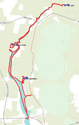
In April 2022, I walked a trail along the south shoreline of the upper Enmore River (maintained by a local watershed group). I had my fishing rod, but no trout were caught. Over the summer, I did two kayak paddles up the Enmore River from the North Enmore bridge. The first paddle in August was for monitoring the multiple NCC properties on the river (3). The second paddle in late September was to check on the impact of hurricane Fiona on the Enmore River.


The August paddle coincided well with high tides and this allowed me to paddle quite far up the large west creek into the newly acquired NCC property (Mill Rd). I went ashore and visited the beaver pond/wetland nearby – but the beavers didn’t show on that day.


On the September paddle (post-Fiona), it was hard to believe that a hurricane had hit PEI a few weeks earlier. The Enmore River looked as pristine as ever. I saw maybe two trees down on the shoreline.  The grasses and sedges were still all standing. For this paddle, I went the full distance between the North Enmore and the Mill Road bridges (2.5 km). On the way back, I tried to visit the large beaver pond on the east side of the river but got blocked by thick vegetation (e.g. cattails).

The Enmore River is pretty much an annual paddle for the enjoyment (scenery & nature) and peacefulness it brings on a beautiful summer day! 


Great Blue Heron in a tree


------------------------------------------------------------------------------------------------------------------------

In 2023, I did a spring and fall paddle on the Enmore River. Here are the tracks and iNaturalist links for those outings.

Spring paddle, 12Jun2023
Link to iNaturalist posts


Fall paddle, 12Oct2023
Link to iNaturalist posts
Link to Google Photo album


Monday, 12 September 2022

St. Peter's Island - Hillsborough Bay, PEI


On September 12, after taking Marc and Danielle to the airport, I made my way toward Rice Point, PEI. On the way, I checked the Nine Mile Creek wharf for a possible launch point, but the boat ramp was the only option there, so I moved on to the end of Hennebury Road. Another launching point to check out next time is the end of Country View Drive, Rice Point. Country View Drive would put you on the protected side of the sandbar and also would be better for low tide conditions.

St. Peter's Island (Merganser kayak, 11 km)

After launching, since the tide was high, I made my way to St. Peter’s Island directly over the sandbar without any issues. I went ashore near the NW corner of the INT property for a break and to have a look around. From there, I paddled around the north end of the island to have a look at the red cliffs of the south shore and the famous lighthouse. The only structure standing on the island today.

West shore view

On the return, I made a shore stop for lunch at the NE tip. By the time I started paddling again, the wind was getting stronger from the SW and the low tide was progressing. From the NE tip, it was a straight 4.5 km (about 1 hour) paddle back to the Hennebury launch point. That was good exercise given the stiff breeze and the choppy waters – probably generated by the big sandbar.


West shore view


Lighthouse

When I do this paddle again, I should leave from the Nine Mile Creek wharf or Country View Drive and reserve lots of time for the more dramatic south shore and maybe a visit to the lighthouse.

The view looking towards Rice Point from the island's NE corner


Friday, 2 September 2022

Malpeque Bay by Va'a Motu


The Va’a Motu outrigger sailing canoe was launched in the summer of 2021 but it was mainly short test sails. For the summer of 2022, I had a new mast and sail ready to go and did several sails on Malpeque Bay. One sail was to Courtin Island in the middle of Malpeque Bay, a couple were south towards the Grand River, and at least three were north towards the sandhills. On a beautiful day with 10 to 30 km/hr winds (preferably westerly), the Va’a Motu was perfect for heading towards the sandhills from the Willie Birch Road launch beach on the west shore of Malpeque Bay.

Va'a Motu Malpeque Bay sails (summer 2022)

The waters around Bird Island are fairly shallow except for the south shore. So, if the winds are not too strong from the west or SW, the south shore is a good option for a shore stop. Otherwise the east (lagoon) sand spits may be a better choice – assuming reasonable high tides. The south and north sides of Bird Island are the best shore walks. Beware of poison ivy! 


Dowitcher, sandhills


Bald Eagle, Hog Island


With the right winds and if the tides are high enough, it’s fun to sail over to the sandhills north of Bird Island and Lennox Island. Behind Bird Island, the sandhills are quite wide and it would be hard to cross over to the gulf side. That’s OK. The sandhill’s inner shoreline has lots of nature and is great to explore. If you sail further west (behind Lennox Island) where the sandhills are narrower, then you have the option of crossing over to the gulf side for a walk. Another option to visit the sandhills is east of Hog Island. Here too, the sandhills are quite wide unless you go to the bitter end (i.e. Fish Island, Malpeque channel).


Hog Island is well-isolated in Malpeque Bay and is always a special place to visit. Hog Island (also known as George Island) is part of the Mi’kmaq nation reserve and permission is required to go ashore/inland. Over the last few years, I always see Bald Eagles on the southern part of Hog Island (nesting, TBD). There’s also a cormorant colony at the south tip of the island. Both the west and east sides are great for shore walks. The north side of Hog Island with the sandhills forms a unique basin that is fun to explore. The basin is over 1 km long but only 200-300m wide, so it’s not so easy to sail under certain wind conditions (better in a kayak). The eastern end of Hog’s north shore is a very special geological place for PEI. It’s the only location where igneous rock (vein of dolerite) can be found on PEI. 


I got the most iNaturalist postings from the August 16 trip. Sightings are HERE.

I’m already looking forward to next summer for more Va’a Motu outings on Malpeque Bay. Now that I have more confidence in the boat, I’ll have to take some sails across to the eastern and southern parts of the bay.


Thursday, 1 September 2022

Brooks River & SW Creek - near Poplar Grove, PEI


There are still some small rivers and creeks in Prince County that I haven’t explored. I started to reduce that list this summer by visiting the Pierre-Jacques Rivers, the Kildare River estuary, and the Brooks River. The Brooks River is near Poplar Grove and flows out to the Conway Narrows at Milligans Wharf. For this first trip to the Brooks River, I launched my kayak at the bridge off SW Road on the Southwest Creek. From the bridge, it’s about a 1 km paddle to the Brooks River.


Brooks River & SW Creek (WD12, 5 km)


Toporama view

For the outbound paddle, I followed the east shore and went to check out the rock dam that blocks the channel to Mt Misery Road and the wetland. It’s hard to believe that this dam would pass an environmental review! The other things of note for the Southwest Creek are the oyster farms and numerous eel traps. From the dam, I paddled into the Brooks River and checked out Milligans Wharf from a distance. 


Southwest River


American Eel trap


One of the first things I noticed once I started paddling upriver toward Conway Cove was a Bald Eagle circling. Once I got into Conway Cove, the eagle had settled on a tree and it let me get pretty close before flying off – so, I got fairly good photos for a change!

Cooperative Bald Eagle

After the Bald Eagle photo shoot, I started heading back. On the way, I noticed a nice public launch point at the end of Wharf Road. I’ll be making use of this launch point next time, and I will also reserve more time to fully explore the other 2 – 3 km of the Brooks River.

Milligans Wharf


SW Creek (south of SW Road)

-----------------------------------------------------------------------------------------------------

Outing on June 13, 2023.
Here's the iNaturalist link for the day.  Click HERE.

Brooks River paddle track, 13Jun2023 (6.5 km)

Tuesday, 23 August 2022

The Pierre-Jacques Rivers, Egmont Bay


This summer, I finally went to explore the two Pierre-Jacques (PJ) Rivers of Egmont Bay. These two rivers flow into the NW part of Egmont Bay, about halfway between Brae Harbour and West Point. The mouths/estuaries of the two rivers are only 2 km apart but they are not related (i.e. they have separate watersheds). The Little PJ has a large estuary as it meets Egmont Bay (Wolfe Inlet and a 2 km sand spit). The Big PJ also has sand barrier banks and a rich salt-water marsh estuary as it comes into Egmont Bay. These unique estuaries should be good habitats for all kinds of sea creatures and birds.  


Pierre-Jacques Rivers (WD12, 10 km)

I didn’t necessarily pick the best day for a kayak trip. The weather was unsettled, and through the paddle, I got some strong winds and rain at times. I launched the WD12 kayak at the end of MacDonald Road (R176). MacDonald Road is a great spot to launch for exploring both rivers and the Glenwood sand spit. I paddled across Wolfe Inlet to the west exit going towards the mouth of the Big PJ River. There were many seagulls and shorebirds gathered on the sand banks at the mouth of the river. I got through the narrow channel into the Big PJ River and found that the water inside was very shallow. I circled a bit taking photos of the many birds in the water and came back out.


WD12 and iffy weather


Greater Yellowlegs

Before heading back to Wolfe Inlet, I went to explore the point to the west of the Big PJ River. Inland, behind that point is a good size salt-water marsh and a flock of Mallard ducks was present. After a shore walk, I headed back towards Wolfe Inlet in the wind and rain. I made a stop at the west end of the sand spit for a break and to decide if I should continue. The weather soon improved, so I decided to finish the planned route and try paddling up the Little PJ River. To my surprise, the Little PJ River isn’t as shallow and I was able to paddle over 1 km upriver. There’s no development on the river for 1.5 km, so it feels pretty isolated. For the short time on the river, I observed and photographed an Osprey, GB Heron, Cedar Waxwing, and a Kingfisher. See my iNaturalist page for the day – HERE.


Osprey


Great Blue Heron

Since the weather was holding, I paddled to the east end of the sand spit for a beach walk and a bite to eat. After lunch, I paddled straight back to MacDonald Road in worsening weather. It was just in time – once ashore and the kayak loaded, the wind got pretty strong and scary!


Kingfisher (typical pose; one of my favourites)

----------------------------------------------------------------------------------------------------------

Pics from my June 21, 2023 paddle trip up the Big Pierre-Jacques River - all the way to Glenwood Pond. I had lunch at the pond before paddling back to the launch at MacDonald Road. Great day!
Here's a link to the iNaturalist postings for the day. CLICK HERE.


Track, 21Jun2023


Pics from my Sep 1, 2023 paddle trip up the Little Pierre-Jacques River - all the way to Hebron Road and back. Another great day on the PJ rivers, Wolfe Inlet, and the Glenwood sand spit!
Here's a link to the iNaturalist postings for the day. CLICK HERE.


Track, 01Sep2023