Wednesday, 4 October 2023

Conway Sandhills, ABC Islands & Gains Creek, PEI


This paddle location is great when you feel like visiting multiple habitats in one outing. In one day trip, you can explore the mainland’s shoreline, the sandhill shorelines (inside and gulf side), the marsh ABC islands, and a wetland creek. On October 4th, I started my paddle from Fitzgerald Road. Fitzgerald is the closest launch point to the ABC islands and Gains Creek. There are two other access points that are excellent for visiting this part of the Conway Narrows – Pete Con Road and Mickie Allan Shore Road. 

Track, 12km, Conway Narrows & Gains Creek

Since I started the paddle late in the morning, I headed straight to the sandhills for some exploring and lunch. Then, on the way back (after lunch), I did an excursion up Gains Creek to check for Bald Eagles, etc. On this trip, I had no time to go ashore on the ABC islands.
Note: With an earlier start (e.g. 9 am), it would be better to explore Gains Creek first, the ABC islands next, and then to the sandhills for lunch/walks. 

Conway's B Island

At my first stop before lunch, I did have time to explore a small spruce and bayberry grove on the sandhills. Usually, I find Savannah Sparrows in this kind of habitat, but today, it was a White-throated Sparrow hanging out in the stunted spruce trees. 

Spruce grove on sandhill

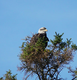
Bird sightings were pretty good on this trip. It included two species of Sparrows (White-throated and Song), a Sanderling shorebird (VU),  and a young Bald Eagle along the shore of Gains Creek. Other nature sightings were posted to iNaturalist – Click HERE.


I would like to try this paddle in the spring to see if there would be a greater abundance of wildlife (e.g. birds, ducks, frogs, etc).


White-throated Sparrow


Song Sparrow


Sanderling (VU in PEI)


Bald Eagle


Sunday, 1 October 2023

Upper Percival River salt-water marshes, PEI


The Percival River is probably the last major river in PEI, with extensive undisturbed salt-water marshes. Luckily, the PEI government owns a fair amount of land along the river, and private land conservation organizations (INT & NCC) have been able to acquire some critical properties. Over the last decade or so, oyster aquaculture farms have invaded the lower Percival River. There are no oyster farms above Black Point on the river. Hopefully, it will stay that way for the foreseeable future. 

Upper Percival public lands (i.e. gov. owned)

For a short description of the Percival River salt marshes, check this NCC article.

Track, 10.5km, upper Percival


Estuary and marsh, upper Percival


The best launch point for the upper Percival is McKies Shore at the end of Mill Road. Planning the outing around high tides is essential when exploring a tidal river, especially side creeks/marshes. So, on Oct 1st, I was launching my 12ft Wood Duck kayak from McKies Shore an hour before high tide – hoping to have peak tides once I got into the creek. It worked out perfectly. I was able to paddle the upper Percival’s west creek all the way to the end. Going further would have required getting out of the kayak and scrambling over a dam and some vegetation – that’s not easy to do in a kayak! 


Upper Percival salt marsh (west)


Beautiful scenery, west marsh
 

Blocked (beaver dam)


Close to the dam, I went ashore on the north side of the creek to explore the marsh and adjacent forest. A walk in the lush cordgrass always feels special, and I like the yellowish colours in the fall. Being the month of October, the damp spruce forest had mushrooms galore. I photographed several species for posting to iNaturalist.


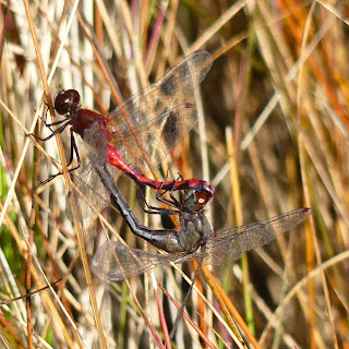
Dragonfly mating in the cordgrass


Golden Spindles fungus/mushroom

On the paddle back to McKies Shore, I crossed the river to explore another salt marsh on the east shore. This east marsh creek is navigable up to Bay Road. The narrow stream continues to a set of beaver ponds (1 km). The narrow stream is not passable due to overgrown vegetation, etc. Here, it should be possible to go ashore and hike on Bay/Gillis Roads to check out the upper beaver dams and ponds.

These upper Percival salt marshes are one of my favourite PEI habitats to explore, and I will definitely be back!

For the iNaturalist postings of the day (Oct 1st, 2023), click HERE.


Friday, 22 September 2023

Freeland Creek, Frederick Cove, PEI


Where Freeland Creek flows into the Conway Narrows

I have paddled and sailed by Frederick Cove several times but never went up Freeland Creek. Freeland Creek is a small creek/wetland that empties into the Conway Narrows at Frederick Cove. The navigable length is short, but exploring all the side creeks/inlets (4) makes for a 6 km paddle. There isn’t much farming along the Conway Narrows coastline, but Freeland Creek is an exception – farming fields border the whole creek.

Track, Freeland Creek, 6.5km

On arriving at Federick Cove, I went to the office of Howard’s Cove Shellfish to get permission to launch my kayak. The office lady had no issues as long as I parked outside the ramp area. The creek was a pleasant paddle with a fair amount of bird life. It may be due to the high amount of aquaculture on the stream. The creek also has some American Eel traps – popular on the north shore inland creeks and rivers.

The launch at Howad's Shellfish, Frederick Shore Rd (or Smith Rd)

The usual birds I see on top of oyster cages are cormorants and gulls, but in Freeland Creek it was a flock of Greater Yellowlegs! I had never seen so many G. Yellowlegs hanging around together. The Belted Kingfisher, Song Sparrow, GB Heron, and the American Black Duck were other bird sightings. 

See my iNaturalist postings for the day – HERE.

Greater Yellowlegs on oyster cages

Frederick Cove is an easy location to start a kayak paddle to explore Freeland Creek, the Conway sandhills, or both!


Friday, 15 September 2023

Trout River, a branch of the Bideford River, PEI


There is more than one Trout River in PEI. This Trout River that I paddled/explored on September 15 is a branch of the Bideford River that flows into Malpeque Bay. The beach at Green Park (near Port Hill) is perfect to put-in/out. Green Park is a free day-use provincial park that accommodates camping (mostly RVs & campers). 

Track, 9km, Trout/Bideford River


I paddled up the Trout River on this outing and explored six side creeks and marsh inlets. Almost the whole length of the Trout River is bordered by farming fields. There is some aquaculture at the mouth of the river across from Green Park. The lower sections of the river feel relatively natural since there are no housing developments. On the way back, I paddled up the Bideford River as far as Griggs Creek before going ashore. Luckily, I was there at high tide. Griggs Creek has a narrow entrance to get inside the sandy estuary.

WD12 kayak on the Trout River (Bideford)

There wasn’t an abundance of nature to capture for iNaturalist. Still, I did get the usual suspects – Kingfisher, Bald Eagle, G. Blue Heron, G. Yellowlegs, Savannah Sparrow, etc.


Greater Yellowlegs


Savannah Sparrow

See my iNaturalist postings for the day – HERE.

The next outing on the Trout/Bideford River will focus on the upper sections of the river (e.g. up to Tyne Valley).

American Black Duck


Monday, 4 September 2023

Duck Creek salt-water marsh, Percival River, PEI


Duck Creek is a salt-water marsh on the western shore of the Percival River. Duck Creek is across the river from McKies Shore (end of Mill Road). From McKies Shore, it’s only 1 km to access the mouth of Duck Creek. You can access Duck Creek without crossing the Percival River by launching at the ramp in Alaska. From Alaska, the creek’s sand-spit estuary is 2 km along the western shore. Both paddle outings I made to Duck Creek in the summer of 2023 were from Alaska. The first paddle on August 13 was with my 17ft Merganser kayak. The 17ft Merganser kayak doesn’t do well in narrow winding creeks – so I did not get too far up Duck Creek that day. 

Tracks, Duck Creek


Duck Creek estuary & salt marsh


I had been to Duck Creek many times before, but this summer, on the September 4th outing, I managed to explore the salt marsh all the way to the first beaver dam in my 12ft Wood Duck kayak. The Duck Creek wetland is isolated from any development and looks pristine. The lower south side of the marsh is Public Lands, but unfortunately, the north side and the upper marsh are still in private hands. 

Public Lands near Duck Creek

There was great scenery on both outings, and I also captured a few nature images with my Lumix FZ300 camera. The nature sightings of the day were all posted to iNaturalist. 

iNaturalist for August 13, click HERE.

iNaturalist for September 4, click HERE.

Lower Duck Creek & marsh


Beaver dam, end of the road!


A next trip to explore more of the Duck Creek salt-water marsh could include an attempt to paddle up the upper creek’s north stream. Also, it would be fun to try and jump the beaver dam and go further west!


A trio of Greater Yellowlegs


Monday, 28 August 2023

Huntley River, an upper branch of the Kildare River


The Huntley River is the west branch of the upper Kildare River. A great location to launch a kayak to explore the Huntley River (or the upper Kildare River) is at the end of Sou-West Road (north from Alberton off Route 12). At the junction where the Huntley River flows into the Kildare, another Kildare River branch goes north – the Montrose River. For the upper Montrose River, I noticed a great launch & parking lot at the Route 152 bridge in Montrose, PEI.

Track, Huntley River, 8 km

After launching my 12ft Wood Duck kayak, I headed up the river following the south shore. It’s only 2 km to Route 152 and Gordon’s Pond. If you were to portage around Gordon’s Pond dam, there could be another kilometre of navigable waterway.

Gordon's Pond dam

The Huntley River had American Eel traps, as many other rivers do on the north side. One eel fisher told me the price was $3.50 per pound in 2023. The current buyer is from New Brunswick (once a week), and the markets are Japan and some European countries.

Eel trap


On the return paddle, I checked up on a few side creeks – including one on the east side of the Kildare River. There was no traffic on the Huntley or Kildare rivers while I was there. Nature sightings were pretty good. On this outing, I got a great photo of a Kingfisher. Kingfishers are usually hard to photograph since they are always on the move or get spooked easily from their perch. I also got a photograph of a Spotted Sandpiper on the river – rare in PEI (S2S3B).

Belted Kingfisher


Spotted Sandpiper


See my iNaturalist postings for the day – HERE.

The next outing in this area will be the Montrose River from the ramp at the Route 152 bridge.

Great Blue Heron


Sunday, 30 July 2023

Up the Brae River, Egmont Bay, PEI


The Brae River is another small river that flows into Egmont Bay (near Brae Harbour). This summer (2023), I was planning to paddle and explore all the rivers of Egmont Bay. For some reason, this would be my first paddle ever up the small, winding Brae River. You could access the river at the Beaton Road bridge, but it would be challenging. So, instead, I decided to put-in/out at the end of Campbell Shore Road. From Campbell Shore Road, it’s a 1 km east paddle to the mouth/estuary of the Brae River.

Track, Brae River, 8km, 30Jul2023

Once inside the estuary, it’s another kilometre to the Beaton Road bridge. This river stretch is about 20-30m wide with some marsh shorelines, forested shorelines, and farm/crop fields. There are also two homesteads along the western side of the river (before the bridge). The church, rectory, and Immaculate Conception Brae cemetery are just west of the bridge on Beaton Road. 

Brae River and marsh, the Beaton Rd church in the background

After the bridge, there are no more structures, but the narrow river is never too far from farmland. The marsh grass and cattails were so tall on this paddle that the farm fields were not visible from the water. As I was zig-zagging up the Brae, I kept running into American Black Ducks. These ducks appeared surprised and shocked – they probably don’t get too much kayak traffic in those narrow sections of the river/creek.

The upper Brae River (the navigable end)

The Brae River was lovely to paddle even though it’s not an entire natural environment. It would be great to try the same paddle early in the spring to see more flora & fauna (especially birds).


American Black Duck


American Black Duck


Cedar Waxwing


Greater Yellowlegs