The Percival River is probably the last major river in PEI, with extensive, undisturbed saltwater marshes. Luckily, the PEI government owns a fair amount of land along the river, and private land conservation organizations (INT & NCC) have been able to acquire some critical properties. Over the last decade or so, oyster aquaculture farms have invaded the lower Percival River. There are no oyster farms above Black Point on the river. Hopefully, it will stay that way for the foreseeable future.
 |
| Upper Percival public lands (i.e. gov. owned) |
For a short description of the Percival River salt marshes, check this NCC article.
|
 | | Track, 10.5km, Black Point Creek |
|
 | | Estuary and marshes, Black Point Creek |
|
The best launch point for Black Point area is McKies Shore at the end of Mill Road. Planning the outing around high tides is essential when exploring a tidal river, especially side creeks/marshes. So, on Oct 1st, I was launching my 12ft Wood Duck kayak from McKies Shore an hour before high tide – hoping to have peak tides once I got into the creek. It worked out perfectly. I was able to paddle Black Point Creek all the way to the end. Going further would have required getting out of the kayak and scrambling over a dam and some vegetation – that’s not easy to do in a kayak!
 |
| Black Point Creek salt marsh (west) |
|
Beautiful fall scenery, Black Point creek
|
 | | Blocked (beaver dam) |
|
Close to the dam, I went ashore on the north side of the creek to explore the marsh and adjacent forest. A walk in the lush cordgrass always feels special, and I like the yellowish colours in the fall. Being the month of October, the damp spruce forest had mushrooms galore. I photographed several species for posting to iNaturalist.
|
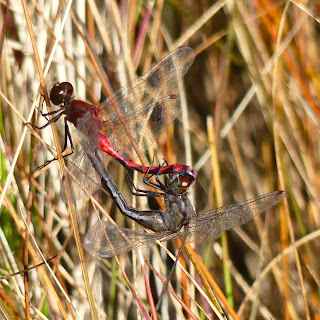
 | | Dragonfly mating in the cordgrass |
|
 | | Golden Spindles fungus/mushroom |
|
On the paddle back to McKies Shore, I crossed the river to explore another salt marsh on the east shore. This east marsh creek is navigable up to Bay Road. The narrow stream continues to a set of beaver ponds (1 km). The narrow stream is impassable due to overgrown vegetation. Here, it should be possible to go ashore and hike on Bay/Gillis Roads to check out the upper beaver dams and ponds.
These upper Percival creeks and salt marshes are some of my favourite PEI habitats to explore, and I will definitely be back!
For the iNaturalist postings of the day (Oct 1st, 2023), click HERE.


For 2024, I made two outings on the upper Percival River. Check "denisag2" on iNaturalist for the dates below for nature sightings of both outings.
ReplyDelete20July2024 (17ft Merganser) - On this trip, I launched at McKie shore and paddled to the top of the river. I went ashore and had a nice walk around the extensive salt-water marsh at the headwaters of the Percival River. I will try again (next year), and some attempts should be made to sync with high tides. Also, a shorter kayak would be best.
23Sep2024 (new SW14 kayak, 8.5 km) - On this second outing to the upper Percival, I paddled my new Shearwater 14 kayak from McKie shore to the large salt-water creek/marsh just north of Black Point. You can only paddle so far, the creek gets narrow and beavers have restricted further access. I did a few walks in the salt marshes and as a bonus I recorded another Seaside Dragonlet (new species to PEI, 2024).
25Sep2025, Shearwater 14 kayak
ReplyDeleteI tried a paddle from McKie Shore to the Black Point Creek. High tide today was 3pm. I got to Black Point Creek around noon. The water level was too low to proceed. Arrival to the creek should be timed to not before one hour before the Egmont Bay high tide. The high tide level may be a factor as well, tbd.