Monday, 5 August 2024

Shipyards & Mill Creeks, Grand River


The Grand River has many tributaries and inlets of various sorts. On the west side of the river near the Grand River church, there are two inlets/creeks that I’ve wanted to check out for a while. These are the Shipyards and Mill Creeks. There’s excellent access to the Grand River at the MacDougall bridge on the SE end towards the church. Names like Shipyards and Mills Creek suggest that this area contributed to the shipbuilding industry of the 19th century. Some research is required.

My paddling track, 6 km (WD12)

After launching, I headed to the mouth of Shipyards Creek for a complete shoreline paddle. There wasn’t enough water to paddle up the creek segment towards route 12 – maybe on a high tide in the spring. Before paddling out of the inlet, I encountered a small flock of Yellowlegs. Usually, you see one or two, so seeing a group was great.

Grand River catholic church


Access to river, R12 bridge


Then, I went under the bridge and did a shoreline paddle of Mills Creek. Again, the water was too shallow to paddle the narrow creek toward Route 131. It looks like 500m should be navigable at high tides. In Mills Creek inlet, I observed the usual pair hanging out together – a bald eagle and a belted kingfisher.

Greater Yellowlegs


R12 bridge near church


Bald Eagle

Belted Kingfisher


These two inlets/creeks make a nice protected paddle, so I will be back – hopefully during higher water levels.

Grand River view


Saturday, 3 August 2024

Sailing the Abrams Village inside channel

Va'a Motu at the sandspit

From Egmont Bay's Cimetiere Road to Abrams Village's fish processing plant, there's a 4.5km navigable channel inside the sandbars. Its average width depends on the tide level but is around 0.5 km. Since this channel is only a few minutes' drive from the cottage, I usually head there when I need a short sail (e.g. to test something or to give somebody a sailing experience). The launch at Cimetiere Rd is pretty good, but some shore areas have thick, sticky mud. The water level to launch and sail in the channel is 0.8m or higher (Cap Egmont). The usual destination is the sand spit on the other side of the Haldimand River (i.e. near the fish plant).

Sailing track, 16 km


On August 3rd, I took the Va'a Motu to the Abrams Village channel mainly for a fun sail. I had expected a west wind, but unfortunately, it was more of a stiff southerly breeze. It took me 15 tacks to reach the sand spit. That was OK, and I can always use more tacking practice. The Va'a Motu tacks pretty well as long as you have the leeboard and rudder well down. If you get in shallow waters (< 1m), you may have to gybe or get the paddle out to bring you about.

Va'a Motu outrigger sailing canoe - some assemble required


After a break on the sand spit, I started my downwind return trip at a good clip. I was soon crossing the lobster boat channel and missed seeing one of the channel markers until it was too late to avoid it! It hit both port side iakos, and luckily, the metal marker buoy was low enough to go under. Phew!

The alternate launch shore for the Abrams Village channel is McGee Road (la cote a Matt). It's a long dirt road that's not always in great shape. But, having a second option is good since the shore access at Cimetiere Road is sometimes not ideal.  

I have sailed out into Egmont Bay (Northumberland Strait) in the past for mackerel fishing but have not done that with the Va'a Motu yet. It's on my list, but the weather needs to be just right.


Friday, 7 June 2024

Exploring the Lower Enmore River


The Enmore River is one of my favourite rivers to visit, but it usually involves outings on the upper Enmore (upriver from the Enmore Road bridge). This year, I did two outings on the lower Enmore River, which joins the larger Percival River before flowing into Egmont Bay.

Lower Enmore River tracks
Blue - MYS15 (9.5 km)
Red - WD12 (0 km)

Accessing the lower Enmore River is not a problem. There are at least four access points that are suitable for kayaks and small boats (Yeos Shore, Portage Shore, Enmans Shore, and the Enmore Road bridge). Most of the time, I prefer to use the Yeos Shore or the Enmore Road bridge launch locations. The Enmans Shore launch is good if you are paddling out to Mossy Point (NCC) and across to Grand Digue Point (INT). I haven't used the Portage location very much, if ever..

In 2024, I did two outings on the lower Enmore River. For the first one (June 7), I launched my small sailing skiff (MYS15) at Yeos Shore and headed towards Enmans Shore. On the way, I stopped at the entrance of MacLaurins Creek to check on a small NCC property. This small NCC property is a salt-water marsh and part of NCC's extensive land ownership around the Enmore and Percival Rivers.

NCC property near Yeos Shore


MYS15 - a sail and oar skiff


Then, I sailed the 2 km or so to the Enmans Shore towards another NCC property (Mossy Point). After a shore walk, I sailed across the mouth of the Enmore River and landed on a large sand spit just before the entrance to  Robbs Creek. I did another shore walk before sailing back along the eastern shoreline to the ramp at Yeos Shore. Sailing to the Enmore Road bridge would be fun on the right day. It would be good to avoid a southerly wind – a westerly or easterly wind would be best!

Enman Shore with Mossy Point in background


On the second outing (August 30), I started at the Enmore Rd bridge with my 12ft Wood Duck kayak. My destination was Robbs Creek – about 2 km downriver. Robbs Creek's water level was just high enough to explore all the inlets and shorelines. There's a small oyster farm operation at the mouth of Robbs Creek – probably a well-protected location from storms. There are no other oyster farms upriver on the Enmore. The larger oyster farms are at the outlet of the Enmore River across from Portage Shore and MacLaurins Creek.


Oyster farming, mouth of Robbs Creek

Greater Yellowlegs shorebird


After exploring the Robbs Creek area, I paddled back upriver, looking for ducks, eagles, etc. When I returned to the bridge, I continued upriver for 1 km to get more paddling and sightseeing. After a couple of exploring shore stops, I returned to the Enmore Road bridge ramp. The Enmore River is always a great place to paddle and explore nature!

Black Duck


Belted Kingfisher on the move


Thursday, 16 May 2024

Glenwood Pond & up-the-creek, PEI


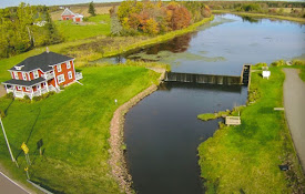
Glenwood Pond is part of the headwaters of the Big Pierre Jacques River. I have paddled the Big PJ River several times from its mouth on Egmont Bay to Glenwood Pond. On this outing (16May2024), I launched into Glenwood Pond and went up the river/creek in search of Brook Trout for dinner. 

Track for the outing (4.7 km)


Good view of Glenwood Pond & house
(not my photo)


Glenwood Pond is an easy launch for a canoe or kayak on either side of the dam (i.e. up or down river). As I started paddling, it was nice to see a few active ducks and birds on the western side of the pond. Once in the creek above the pond, it's navigable for about 0.5 km. It's not a long paddle, but it's always great to zigzag around in a small creek in the spring. On the way back, I did surprise a Muskrat swimming about – posted to iNaturalist, but it hasn't been IDed yet. Sometimes, it's hard to tell a Muskrat from a Beaver in the water – unless there's a tail splash!


Blue-winged Teal ducks
 

Tree Swallows


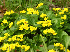
Marsh Marigold


After returning to the pond's parking lot, I had lunch. Then, I launched the canoe below the dam for a short downriver paddle and some nature viewing. I wasn't disappointed. In the 1 km downriver stretch, I observed an Osprey, Blue Heron, and large patches of bright Marsh Marigold.

No Brook Trout were seen or caught on this river/pond trip!

For the May 16 Glenwood nature observations, check my iNaturalist account HERE.


Colourful oyster skiffs on Glenwood Pond


Wednesday, 4 October 2023

Conway Sandhills, ABC Islands & Gains Creek, PEI


This paddle location is great when you feel like visiting multiple habitats in one outing. In one day trip, you can explore the mainland’s shoreline, the sandhill shorelines (inside and gulf side), the marsh ABC islands, and a wetland creek. On October 4th, I started my paddle from Fitzgerald Road. Fitzgerald is the closest launch point to the ABC islands and Gains Creek. There are two other access points that are excellent for visiting this part of the Conway Narrows – Pete Con Road and Mickie Allan Shore Road. 

Track, 12km, Conway Narrows & Gains Creek

Since I started the paddle late in the morning, I headed straight to the sandhills for some exploring and lunch. Then, on the way back (after lunch), I did an excursion up Gains Creek to check for Bald Eagles, etc. On this trip, I had no time to go ashore on the ABC islands.
Note: With an earlier start (e.g. 9 am), it would be better to explore Gains Creek first, the ABC islands next, and then to the sandhills for lunch/walks. 

Conway's B Island

At my first stop before lunch, I did have time to explore a small spruce and bayberry grove on the sandhills. Usually, I find Savannah Sparrows in this kind of habitat, but today, it was a White-throated Sparrow hanging out in the stunted spruce trees. 

Spruce grove on sandhill

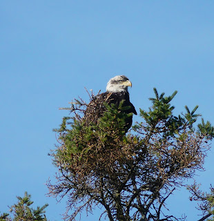
Bird sightings were pretty good on this trip. It included two species of Sparrows (White-throated and Song), a Sanderling shorebird (VU),  and a young Bald Eagle along the shore of Gains Creek. Other nature sightings were posted to iNaturalist – Click HERE.


I would like to try this paddle in the spring to see if there would be a greater abundance of wildlife (e.g. birds, ducks, frogs, etc).


White-throated Sparrow


Song Sparrow


Sanderling (VU in PEI)


Bald Eagle


Sunday, 1 October 2023

Upper Percival River salt-water marshes, PEI


The Percival River is probably the last major river in PEI, with extensive undisturbed salt-water marshes. Luckily, the PEI government owns a fair amount of land along the river, and private land conservation organizations (INT & NCC) have been able to acquire some critical properties. Over the last decade or so, oyster aquaculture farms have invaded the lower Percival River. There are no oyster farms above Black Point on the river. Hopefully, it will stay that way for the foreseeable future. 

Upper Percival public lands (i.e. gov. owned)

For a short description of the Percival River salt marshes, check this NCC article.

Track, 10.5km, upper Percival


Estuary and marsh, upper Percival


The best launch point for the upper Percival is McKies Shore at the end of Mill Road. Planning the outing around high tides is essential when exploring a tidal river, especially side creeks/marshes. So, on Oct 1st, I was launching my 12ft Wood Duck kayak from McKies Shore an hour before high tide – hoping to have peak tides once I got into the creek. It worked out perfectly. I was able to paddle the upper Percival’s west creek all the way to the end. Going further would have required getting out of the kayak and scrambling over a dam and some vegetation – that’s not easy to do in a kayak! 


Upper Percival salt marsh (west)


Beautiful scenery, west marsh
 

Blocked (beaver dam)


Close to the dam, I went ashore on the north side of the creek to explore the marsh and adjacent forest. A walk in the lush cordgrass always feels special, and I like the yellowish colours in the fall. Being the month of October, the damp spruce forest had mushrooms galore. I photographed several species for posting to iNaturalist.


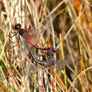
Dragonfly mating in the cordgrass


Golden Spindles fungus/mushroom

On the paddle back to McKies Shore, I crossed the river to explore another salt marsh on the east shore. This east marsh creek is navigable up to Bay Road. The narrow stream continues to a set of beaver ponds (1 km). The narrow stream is not passable due to overgrown vegetation, etc. Here, it should be possible to go ashore and hike on Bay/Gillis Roads to check out the upper beaver dams and ponds.

These upper Percival salt marshes are one of my favourite PEI habitats to explore, and I will definitely be back!

For the iNaturalist postings of the day (Oct 1st, 2023), click HERE.