Thursday, 27 July 2023

Nebraska Creek, Grand River, PEI


Nebraska Creek was a new kayaking destination for me in 2023. I have paddled and sailed on most of the Grand River but never ventured up the Nebraska Creek tributary. Nebraska Creek flows from the Miscouche peat lands off the Western Road to the Grand River, which flows NE into Malpeque Bay.

Track, 7km, 27Jul2023

The launch is just east of the Route 12 bridge. There’s an access trail to the water’s edge, but it requires a truck or 4WD vehicle. With Anne’s Toyota Corolla, I unloaded the kayak on Route 12 and used my 2-wheel kayak cart for the 100m trek to the creek. After launching, I checked the cottages, cabins, and trailers in the large creek/inlet to the east that borders the Nebraska Road. The water was very shallow and weedy in the east channel, so I did not make it all the way to the Nebraska Road bridge. Most structures (cottages/cabins, sheds, etc.) that border Nebraska Road don’t look great, and some appear abandoned.


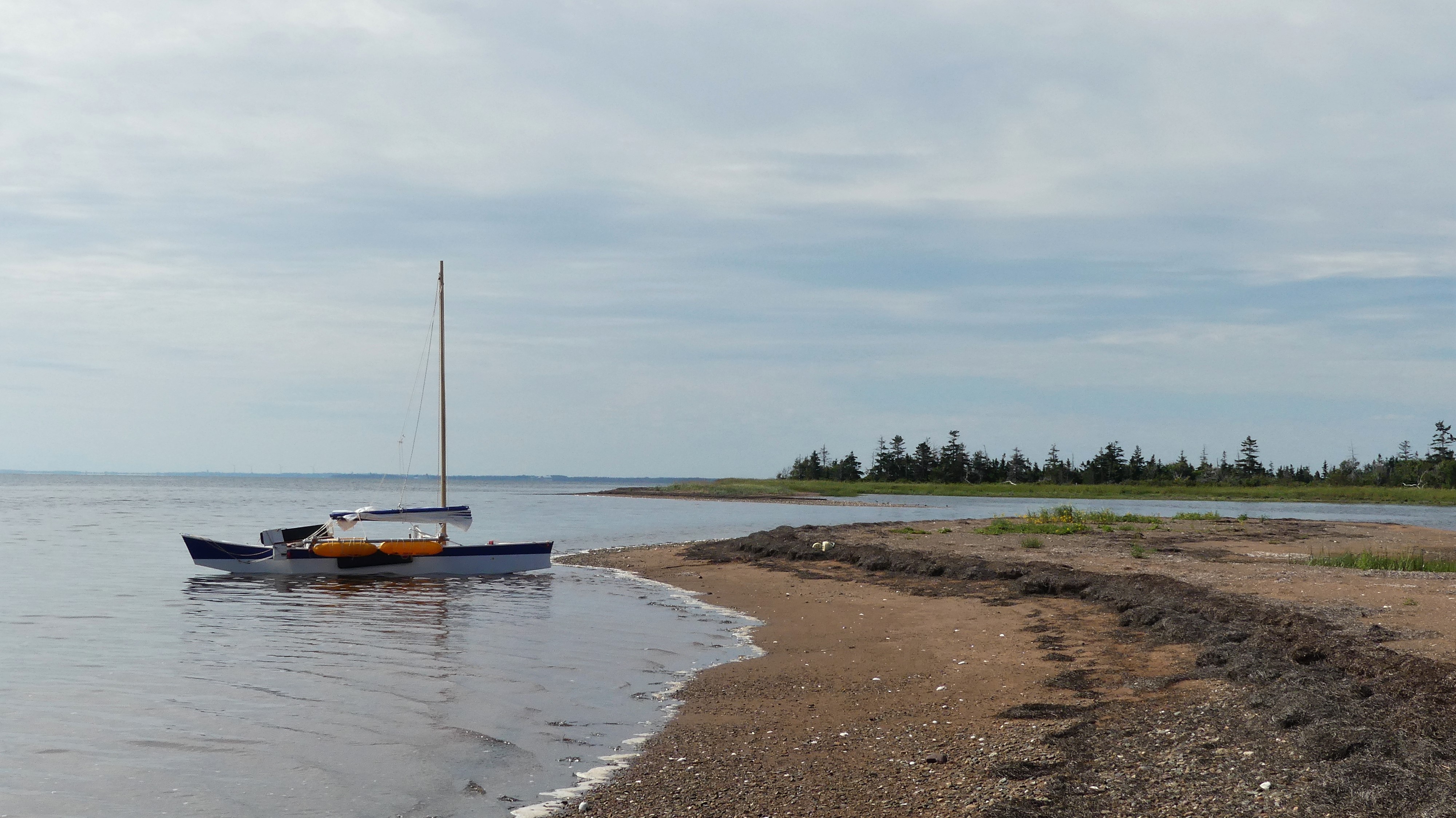
After exiting the east side inlet, I headed upstream (south), following the east shore to better inspect INT’s Nebraska Creek Natural Area. In paddling upstream, the creek feels pretty isolated and undisturbed (from the seat of a kayak). But, on Google Earth, you can see large areas of logging (especially on the western side). Also, less than 1 km to the south of where I was paddling is the large commercial Miscouche Peat mine (150 acres). And to the west (about 2 km) is the East Prince Waste Management Facility (i.e. the dump).  

The lower Nebraska Creek

I paddled about 2.5 km up the creek before being blocked by low water levels and debris. The stream was turning eastward at this point, and another 300m or so, I would have reached a beaver dam/pond area. On the upper stretch of Nebraska Creek, there is only one development – one cottage/home on the west bank with a 500m access from Route 122 (Allen Rd). The property seems to include a small man-made pond near the creek.

The upper Nebraska Creek

The iNaturalist postings for the day can be found by clicking HERE.

The Nebraska Creek paddle was quite good once I left the cottage/cabin area. I signed up with INT as the prime Guardian for the MapleCross Nebraska Creek NA, so I’ll be back on a yearly basis. Next year, try to reach the upper creek at the peak of high tides/waters.


Belted Kingfisher


Solitary Sandpiper

Note 1: The Route 12 Nebraska Creek wooden bridge looks pretty scary from under. I hope it’s on the repair/replacement list sooner rather than later!

Note 2: Nebraska is of aboriginal origin (North America) and means “flat water.” I don’t know if that was the Mi’kmaq local meaning or how the Nebraska Creek came to have its name.


Sunday, 9 July 2023

The Ox and Sheep Rivers, PEI


The Ox and Sheep Rivers are two small streams flowing into the Enmore/Percival estuary and Egmont Bay. Due to their size, it’s hard to call them rivers, but that shows up on all the maps. Creeks would be a better match to other streams in the area (e.g. Beatons Creek, Baptiste Creek, etc). 

Track, 7.5km, 09Jul2023

On this outing, I launched my WD12 kayak at Higgins Wharf to reach the mouth of the two small rivers. The other put-in option is the end of Moore Road (Yeos Shore). Moore Road is a slightly longer paddle to the Ox/Sheep Rivers, but it would be a better launch site. Higgins Wharf can be a mess, smelly, and busy sometimes. The day was somewhat hazy when I started from Higgins Wharf, but it eventually cleared up. Unfortunately, the tide was going down, so I did not waste too much time getting up the Ox River. I had no problem getting to the Route 11 bridge, but 200m further upstream, the way was blocked by a large tree. The south side of the Ox River is mostly farm fields but no building structures. 

Common Tern

I tried to go up the Sheep River on the return paddle, but the water level was too low. So, it was a quick paddle back out of the Ox/Sheep estuary before getting stuck in the bottom mud. On returning to Higgins Wharf, I went by an oyster aquaculture. I got some scenery photos and the usual close-up pics of Cormorants resting on the black flotation boxes.

Double-crested Cormorants hanging out

The iNaturalist postings for the day can be found by clicking HERE.

The Ox/Sheep River paddle was a bit more interesting than I would have thought. I will do it again but at higher water/tide levels.


The lower Ox River


The upper Ox River (just east of Route 11 bridge)


Sunday, 2 July 2023

Jacques River, Baie-Egmont, PEI


The Jacques River is the closest to our summer home in St. Chrysostome (aka Rocky Point). The Jacques River is also the only river in PEI that I’ve been able to do a loop outing (it only requires a 700m walk).


Track, Jacques River loop, 5km

The put-in is at the end of Cimetiere Road on Egmont Bay. The Cimetiere Road is also a place to launch my Va’a Motu outrigger sailing canoe. The put-out is the Arsenault Pond, and then a 700m walk back to the end of Cimetiere Road (and your vehicle). This paddle (as most small rivers in PEI) is best done at high tides. Ideally, for small PEI rivers, you should plan to be heading upriver an hour before high tide and end the paddle 2 to 3 hours after high tide. 

Jacques River estuary into Egmont Bay

The paddle from Cimetiere Road to the mouth of the Jacques River is about one km. On this paddle, I landed on the sandy shore just south of the river’s entrance/estuary. Before I started again, seeing an Osprey circling and fishing over the bay just out from the river was great.

The south creek salt-marsh

The most natural part of the paddle is the first kilometre or so – before you get to the farm fields, homes, and roads. The first kilometre has two side creeks/marshes to explore. The south one (towards McGee Road) is more remote and quite lovely. The east creek goes towards Route 11. I did spot a Muskrat in the east stream, but he disappeared before a photo could be taken. By early July, both creeks were somewhat blocked by marsh grass & cattails. I’ll have to try this paddle early in the spring on a high/spring tide to see how much further it’s possible to paddle on those creeks.


East creek


Blue Flag Lily

After the east creek, it’s not more than 1.5 km to the Arsenault Pond. The river gets narrower and goes under two bridges before reaching the pond. The Route 11 bridge is older and relatively low – it could be trouble when the water level is a bit higher.

The iNaturalist postings for the day can be found by clicking HERE.

An Osprey fishing in Egmont Bay at the mouth of the Jacques River


Friday, 16 June 2023

Ellis River, Days Corner to Wellington, PEI


Ellis is the local name for this stretch of the upper Grand River that goes through Wellington. Today, the official name for the whole river is Grand River. At one time, it was called the Ellis River – especially for the upper reaches. Ellis is likely from William Ellis, an early shipbuilder in the Port Hill area. So, if that's confusing, the Mi'kmaq name for the Grand River is Amasisipukwek (meaning, "the river where it stretches out and follows far into the distance"). 

Track, 5.5 KM, 16Jun2023

So, on June 16, I went to the Western Road bridge at Days Corner and launched my WD12 kayak on the Grand/Ellis/ Amasisipukwek River. The launch site is on the bridge's north side (downriver). It is suitable for a kayak/canoe put-in/out (just be careful of the highway traffic).


Launch site - the Days Corner hwy 2 bridge

As you go under the bridge, you'll first notice the graffiti on the bridge's walls. There's graffiti on the Route 2 Highway and Wellington bridges – but it's hard to determine what it means!


Hwy 2 bridge


Wellington bridge

The distance from the Highway 2 bridge to Wellington is about a 2.5 km paddle. It's a good paddle without much development until you get close to Wellington. I came across only one side creek that was navigable to explore. Sightings of birds were not overly high, but it could have been the time of day or season. I got to observe a pair of beautiful Green-winged Teal ducks. In one area, I came across a mat of Creeping Juniper, a rare plant in PEI (S2). Other nature sightings posted to iNaturalist can be found HERE.


Green-winged Teal ducks


Common Grackle

Along the way to Wellington (especially below the lagoon), I did come across large patches of green algae in the river. From a PEI government web page, "Mats or green scum are generally caused by a large growth (or bloom) of water plants or algae. Duckweed and filamentous algae are the most common causes in freshwater ponds. Sea lettuce forms mats in many Island estuaries."

Algae mats (species tbd)

Next time I paddle this stretch of the Ellis/Grand River, I should try to jump the dam in Wellington and see how far upstream I can paddle.

Thursday, 29 September 2022

Paddling & exploring on the Enmore River


The Department of the Environment for PEI has the Enmore River labelled as having excellent water quality. This is not hard to believe. Every time that I go paddling on the Enmore River, I feel that this small river is still pristine! The Enmore is currently unspoiled by farming, fishing, or any other kinds of industries. There has been logging in the area over the years but there’s nothing large-scale taking place at the moment. 


August 13 paddle (5.8 km)


Sep 29 paddle (post Fiona)

In April 2022, I walked a trail along the south shoreline of the upper Enmore River (maintained by a local watershed group). I had my fishing rod, but no trout were caught. Over the summer, I did two kayak paddles up the Enmore River from the North Enmore bridge. The first paddle in August was for monitoring the multiple NCC properties on the river (3). The second paddle in late September was to check on the impact of hurricane Fiona on the Enmore River.


The August paddle coincided well with high tides and this allowed me to paddle quite far up the large west creek into the newly acquired NCC property (Mill Rd). I went ashore and visited the beaver pond/wetland nearby – but the beavers didn’t show on that day.


On the September paddle (post-Fiona), it was hard to believe that a hurricane had hit PEI a few weeks earlier. The Enmore River looked as pristine as ever. I saw maybe two trees down on the shoreline.  The grasses and sedges were still all standing. For this paddle, I went the full distance between the North Enmore and the Mill Road bridges (2.5 km). On the way back, I tried to visit the large beaver pond on the east side of the river but got blocked by thick vegetation (e.g. cattails).

The Enmore River is pretty much an annual paddle for the enjoyment (scenery & nature) and peacefulness it brings on a beautiful summer day! 


Great Blue Heron in a tree


------------------------------------------------------------------------------------------------------------------------

In 2023, I did a spring and fall paddle on the Enmore River. Here are the tracks and iNaturalist links for those outings.

Spring paddle, 12Jun2023
Link to iNaturalist posts


Fall paddle, 12Oct2023
Link to iNaturalist posts
Link to Google Photo album


Monday, 12 September 2022

St. Peter's Island - Hillsborough Bay, PEI


On September 12, after taking Marc and Danielle to the airport, I made my way toward Rice Point, PEI. On the way, I checked the Nine Mile Creek wharf for a possible launch point, but the boat ramp was the only option there, so I moved on to the end of Hennebury Road. Another launching point to check out next time is the end of Country View Drive, Rice Point. Country View Drive would put you on the protected side of the sandbar and also would be better for low tide conditions.

St. Peter's Island (Merganser kayak, 11 km)

After launching, since the tide was high, I made my way to St. Peter’s Island directly over the sandbar without any issues. I went ashore near the NW corner of the INT property for a break and to have a look around. From there, I paddled around the north end of the island to have a look at the red cliffs of the south shore and the famous lighthouse. The only structure standing on the island today.

West shore view

On the return, I made a shore stop for lunch at the NE tip. By the time I started paddling again, the wind was getting stronger from the SW and the low tide was progressing. From the NE tip, it was a straight 4.5 km (about 1 hour) paddle back to the Hennebury launch point. That was good exercise given the stiff breeze and the choppy waters – probably generated by the big sandbar.


West shore view


Lighthouse

When I do this paddle again, I should leave from the Nine Mile Creek wharf or Country View Drive and reserve lots of time for the more dramatic south shore and maybe a visit to the lighthouse.

The view looking towards Rice Point from the island's NE corner


Friday, 2 September 2022

Malpeque Bay by Va'a Motu


The Va’a Motu outrigger sailing canoe was launched in the summer of 2021 but it was mainly short test sails. For the summer of 2022, I had a new mast and sail ready to go and did several sails on Malpeque Bay. One sail was to Courtin Island in the middle of Malpeque Bay, a couple were south towards the Grand River, and at least three were north towards the sandhills. On a beautiful day with 10 to 30 km/hr winds (preferably westerly), the Va’a Motu was perfect for heading towards the sandhills from the Willie Birch Road launch beach on the west shore of Malpeque Bay.

Va'a Motu Malpeque Bay sails (summer 2022)

The waters around Bird Island are fairly shallow except for the south shore. So, if the winds are not too strong from the west or SW, the south shore is a good option for a shore stop. Otherwise the east (lagoon) sand spits may be a better choice – assuming reasonable high tides. The south and north sides of Bird Island are the best shore walks. Beware of poison ivy! 


Dowitcher, sandhills


Bald Eagle, Hog Island


With the right winds and if the tides are high enough, it’s fun to sail over to the sandhills north of Bird Island and Lennox Island. Behind Bird Island, the sandhills are quite wide and it would be hard to cross over to the gulf side. That’s OK. The sandhill’s inner shoreline has lots of nature and is great to explore. If you sail further west (behind Lennox Island) where the sandhills are narrower, then you have the option of crossing over to the gulf side for a walk. Another option to visit the sandhills is east of Hog Island. Here too, the sandhills are quite wide unless you go to the bitter end (i.e. Fish Island, Malpeque channel).


Hog Island is well-isolated in Malpeque Bay and is always a special place to visit. Hog Island (also known as George Island) is part of the Mi’kmaq nation reserve and permission is required to go ashore/inland. Over the last few years, I always see Bald Eagles on the southern part of Hog Island (nesting, TBD). There’s also a cormorant colony at the south tip of the island. Both the west and east sides are great for shore walks. The north side of Hog Island with the sandhills forms a unique basin that is fun to explore. The basin is over 1 km long but only 200-300m wide, so it’s not so easy to sail under certain wind conditions (better in a kayak). The eastern end of Hog’s north shore is a very special geological place for PEI. It’s the only location where igneous rock (vein of dolerite) can be found on PEI. 


I got the most iNaturalist postings from the August 16 trip. Sightings are HERE.

I’m already looking forward to next summer for more Va’a Motu outings on Malpeque Bay. Now that I have more confidence in the boat, I’ll have to take some sails across to the eastern and southern parts of the bay.