The best launch point to visit and explore the northern section of the
Cascumpec Sandhills is the end of Northport Shore Road in western PEI. The
Northport harbour is 1 km to the north, and Oulton Island is 400m directly
across from the launch point. The 400m between the sandy launch point and
Oulton Island is the channel used by Northport boat traffic to access Cascumpec
Bay, Foxley River, and Mill River. So it can be reasonably busy with fishing
and recreational boat traffic.
|
 | Cascumpec sandhills (MYS15 9.6 km)
|
|
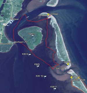 | | Google Earth track view |
|
On this beautiful day, the tide wasn’t going to be all that high, but I
hoped to have enough wind to sail along in Cascumpec Bay towards Black Point
(south) while avoiding all those large sandflats. Sometimes things work out - the sun is out,
the tides are right, and the wind is in the sweet spot (i.e. not too light and
not too strong). Today, the wind stayed weaker than expected for the north
shore, so lots of rowing.
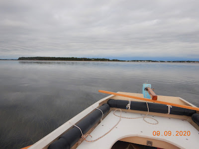 |
| MYS15 under oars (Northport in the background) |
|
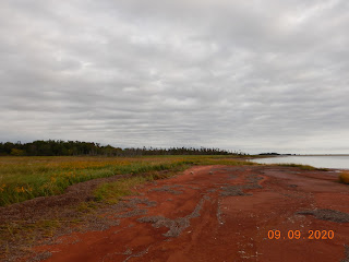 | | Oulton Island east shoreline |
|
 | | Oyster farming east of Oulton Island |
|
So, there had to be a change of plans for the day. Under oars, I wasn’t
getting too far. In calm weather, I can average 3 – 4 km/hr when rowing the
MYS15 skiff. When sailing, the average speed can be up to 6 km/hr depending on
many factors (wind, tack, etc.). After
leaving the launch point under oars, I headed for the south tip of Oulton
Island and had a walk around while waiting for more wind. But no wind came, so I decided to make for
SHC10 (Sandhill Channel 10) instead of SHA15 (Sandhill Access 15). SHC10 was
only about 1.5 km away, but still took a bit of time to get there – rowing in
shallow water isn’t very fast. I landed
on the sandflat at SHC10 and dropped the anchor in shallow waters. The SHC10
sandflat is about 60 hectares, but the next one at Goose Harbour is enormous (150
hectares).
|
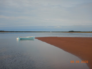 | | MYS15 at anchor (SHC10) |
|
 | | The SHC10 sand flat |
|
At
SHC10, I did spend some time exploring the sand flats and photographing some
nature sightings. It was also interesting to see that the locals are still
putting out net traps for fish (eels, I think). From here, I concluded the wind
would not cooperate for going any further (south) along the sandhill shore, so
I decided to make it a day for exploring the north end of the Cascumpec Bay
sandhills.
|
 | | Fish traps off SHC10 (usually eels) |
|
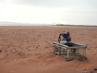 | | A typical gulf-side beach view |
|
Exploring the northern part of the Cascumpec Sandhills means going
through the shallow water behind (east) Oulton Island. My destination was the
lighthouse on the north tip of the sandhill (SHA05). Once I got there, it was time for a short
walk along the beach (gulf side) and lunch. There wasn’t anybody at the
lighthouse, so I made use of their picnic table for lunch. The lighthouse is
privately owned and sits on a 3 km section of the Cascumpec Sandhills that is
still not protected.
|
|
 | | Cascumpec lighthouse (private) |
|
Believe it or not, after lunch, a light breeze came up – making it
worthwhile to set up the sail on my old skiff (MYS15). I made it home under sail, but I didn’t take
the best route. I made the mistake of staying too close to Oulton Island and
got myself into pretty shallow waters. The MYS15 came close to getting stuck in
grass and mud, but eventually, I made it into the Northport channel and deep
water. From here, it was a pleasant sail
back to the launch point.
Irrespective of the weather/wind, I always have a great time when out in
one of my boats exploring PEI’s remote sandhills! But, for this trip around Oulton Island and
the northern Cascumpec Sandhill, it’s probably better done by kayak (next
time).
|
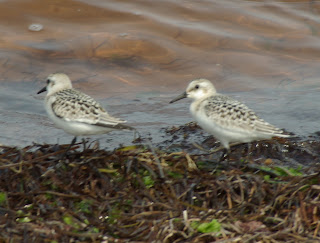 | | Sanderlings |
|
 | | Ruddy Turnstone |
|
|
 | | Northern Moon Snail |
|
 | | Red Fox footprint |
|
|
 | | Common Glasswort |
|
 | | Starry False Solomon's Seal |
|
 |
| Semipalmated Plover |


No comments:
Post a Comment
Note: only a member of this blog may post a comment.